The heat wave is almost over, but first we still have to get through another day of the hottest temperatures not seen in some areas in more than 10 years — or in some cases, not seen in six decades.
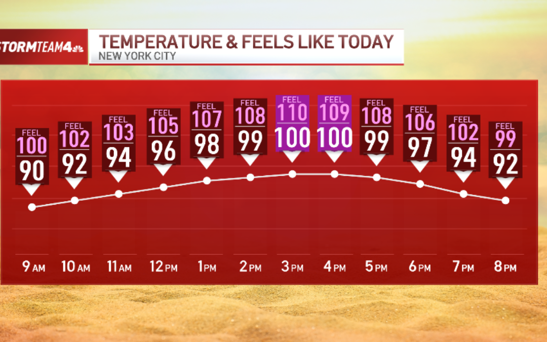
Friday features more dangerous heat and humidity, with highs peaking at 100 degrees around New York City. The humidity will make that feel even worse, with heat index levels around 110 by the mid afternoon.
Thursday featured temperatures in Central Park hit 100 for the first time since 2012, and tied a record high set in 1966. Central Park could hit triple digits again, but may not break the record for the day, which was set at 103 (again in 1966, which must have been a truly brutal heat wave to endure).

It will only cool off slightly through the evening, as temperatures will still be north of 90 degrees by the time the sun is setting, and will still feel even hotter. Not the kind of weather one would want to be wearing, say, a wedding dress or suit in, for example.
Where Friday differs from Thursday is the chance for severe weather in the evening. The storm coverage will likely be spotty, but given the heat and humidity present to fuel them, any storms that do develop have the potential for damaging wind gusts and heavy downpours, which could lead to flash flooding. Large hail could also be possible.

Looking ahead to Saturday, it will technically be cooler outside, but don’t get your hopes up for much: Temperatures will still be scorching in the 90s, and it will feel close to 100 degrees.
The storm threat Saturday is of greater concern. Isolated storms in the afternoon, then more widespread in the evening and late night that could interfere with fireworks plans. Damaging wind is again the primary concern, but flash flooding is possible as well.

For those looking to head to the beach to cool down in the surf, dangerous rip currents are expected Friday evening at all ocean-facing beaches. That risk is low on Saturday.
More rain is in the forecast for Sunday, which may mark the end of the heat wave. Temperatures will likely stay in the 80s, which is much more seasonable, though still plenty of humidity to make it feel uncomfortable to be outside.
There is also a chance for rain Monday that comes with a flooding risk, but accompanying that is a significant cool down.

