Thursday brought intense, brutal heat which fueled evening thunderstorms throughout the New York City area.
What does Friday have in store? More intense, brutal heat which will fuel evening thunderstorms throughout the New York City area.
It will be another hot and humid day with highs reaching the mid 90s for some. And pair that with oppressive humidity, and it will feel near or above 100 in the afternoon.
A heat advisory is in effect through Friday afternoon. The advisory covers the whole tri-state except for Eastern Suffolk County on Long Island and the Catskills and Poconos Mountains.
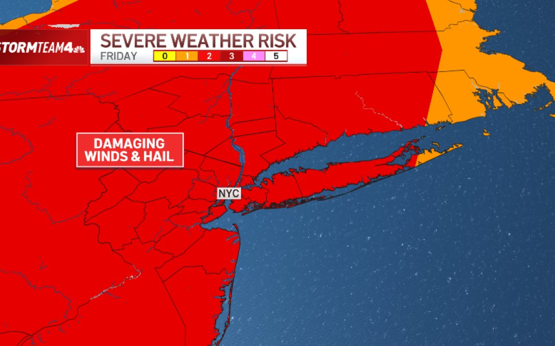
Then, just like on Thursday, there’s a chance for strong to severe storms to roll through the tri-state starting in the late afternoon and lasting well into the evening.
Once again, damaging straight-line wind gusts are the main threat. Hail and isolated flash flooding are possible.


The flash flood threat is not expected to be widespread, but rainfall rates could be intense at times. That could be problematic for low-lying areas.
Damaging straight-line winds remain the primary threat, with northern and central New Jersey most likely to experience those.
Timing remains important. If storms arrive too late in the evening, instability may already be weakening, which could limit storm coverage and intensity. So, while storm chances have been lowered somewhat, the risk for a few strong to severe storms remains on the table Friday afternoon and evening.
Check the latest weather alerts for your neighborhood here.

When will the extreme heat end?
The heat remains a major story.
Temperatures are expected to return to the upper 80s and lower 90s, with dew points still in the upper 60s to lower 70s. That combination will push heat index values back into the mid 90s to lower 100s.
After two days of heat index readings at that level, any extended periods of time spent outside during the hottest part of the day should be avoided. It is also important to stay hydrated, avoid strenuous activity and stay in the shade as much as possible to avoid heat stroke or heat exhaustion.
The good news: Drier air will move into the region Friday night, leaving the weekend hot but much less humid.
Saturday and Sunday, high temperatures will hover in the upper 80s for most areas with heat index readings closer to 90. It won’t be until Monday that cooler air moves in and temperatures return to more normal levels for mid-June.


By the weekend, drier air that moves into the region will drastically cut our rain chances. But it looks like a chance for showers and storms moves back in late Sunday afternoon and evening.
Expect dry skies Saturday and early Sunday with plenty of sunshine: Great news for Knicks watch parties for Game 5 of the NBA Finals Saturday night and the Puerto Rican Day Parade Sunday afternoon.
Most of Sunday should be sunny and hot, with highs in the upper 80s to lower 90s. Dew points are expected to be in the lower 60s, so heat hazards are not a major concern at this time.
The main concern comes later in the day as an upper-level disturbance and cold front approach. Forecast models show a decent signal for rainfall and storms along the front, with instability extending into northeast New Jersey. The Storm Prediction Center has already placed NYC and areas north and west in a Day 4 Slight Risk, which highlights the potential for organized severe weather.

