After 90-degree heat and blazing sun for most areas through Saturday afternoon, a cold front will generate potentially severe storms throughout much of the tri-state Saturday evening, with damaging straight-line wind posing the greatest threat.
During the day, Saturday will be much like Friday, with highs around 90 or so. Fortunately, dew points (humidity) remain low, so there will be no heat index to contend with. No heat advisories are expected to be issued over the weekend.
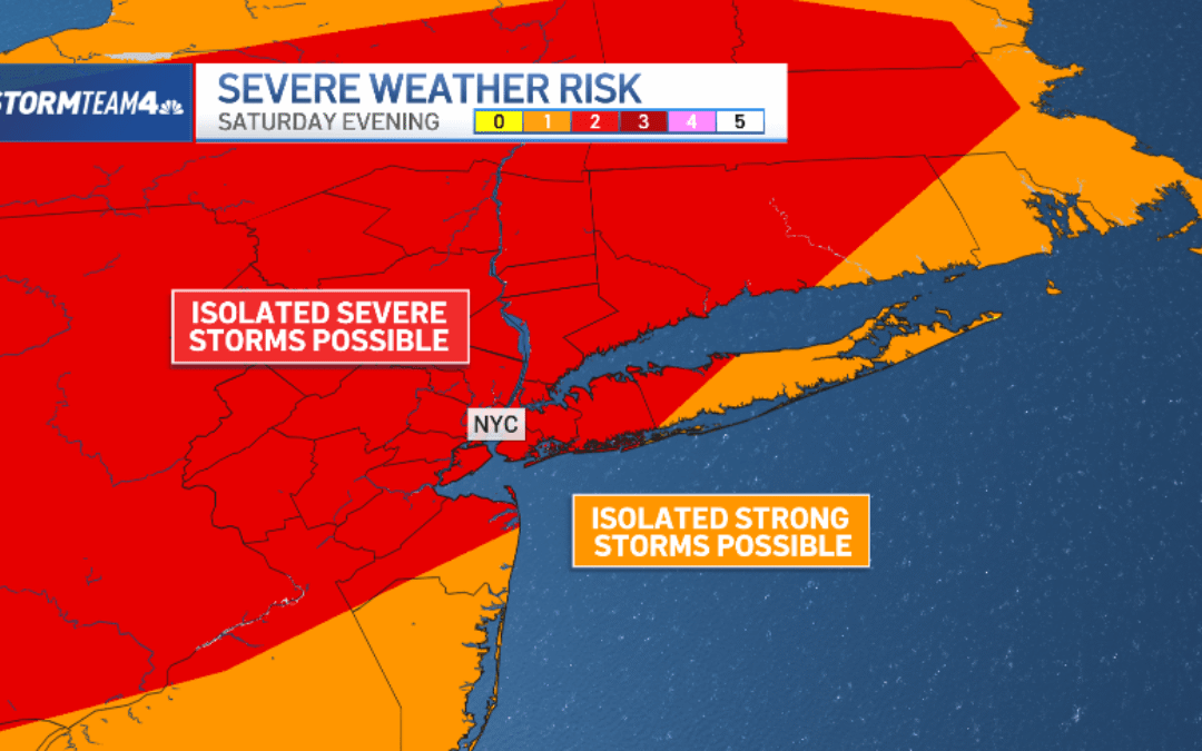
But a line of potentially powerful storms will bring the day to a wet and windy end.
On a scale from one to five, the threat for most of the area, including New York City, will be at Level 2. Areas north and west of the city will have the greatest chance to see strong to severe storms.
Storms will move into the Catskills by late afternoon, around 5 or 6 p.m. They will make their way into the New York City area by mid-evening. Most of the storms will have cleared the area by 10 or 11 p.m.
Some of the storms could produce damaging straight-line winds, most likely in northwestern New Jersey, the Catskills and Hudson Valley. Hail is a secondary threat from the storms. Tornadoes are not likely.

Rainfall rates from some storm cells could be high: over an inch per hour. Fortunately, the storms will be moving along at a good clip, so overall rain accumulation will remain below an inch in most areas, which keeps the flood threat low.
That said, isolated flash flooding can never be ruled out when strong storms move through, especially in low-lying areas. NYC Mayor Zohran Mamdani advised residents to be prepared for travel delays as a result of the weather.

Behind the storms, conditions will calm down considerably by late Saturday night.
Slightly cooler air behind the cold front will keep temperatures in the 80s on Sunday, though a touch warmer than usual. It will be mainly dry with (orange and) blue skies for much of the day, though a spot splash-n-dash light shower in the afternoon can’t be ruled out.
Temperatures moderate somewhat on Sunday, but will remain warmer than usual. Sunday will be mostly dry, with (orange and) blue skies for much of the day, though a stray shower during the warmest part of afternoon can’t be ruled out. Don’t cancel any outdoor plans, though. Most of the area will remain dry all day.
Much of the rest of the week is largely quiet, starting out with comfortable temperatures before 90 degree heat returns late-week. Rain chances remain meager.
Hourly radar breakdown for Saturday storms
6 p.m.

7 p.m.

8 p.m.

9 p.m.

10 p.m.

11 p.m.

