As the tri-state area gets its first real taste of summer weather, Wednesday promises to be the hottest day for many since the middle of August last year.
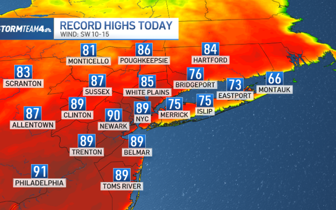
The high in New York City should top out at 89, which would beat the current record of 87 set in 1941.
Some areas could reach 90 or slightly above!

Our heat comes from a big ridge of high pressure to our south, centered over the Western Atlantic Ocean.
It’s pumping unusually warm air from the Southern U.S. directly into the tri-state. The west-southwest wind direction also helps cut off the sea breeze at the coast and allows beach areas to feel the summer preview, too.

A few isolated storms may accompany the heat on Wednesday night – along and south of a stationary front draped over upstate New York.
The storms will feed on the energy of our warm air mass and one or two could reach severe limits, with damaging straight-line wind the main threat. Most areas will stay dry, however, as these storms will not be widespread. Check the latest weather alerts for your neighborhood here.

Temperatures on Thursday will be similar to Wednesday’s, thanks to our persistent west-southwest wind. It’ll feel more like July than April.

After Thursday, we begin our trend toward more normal weather, with highs dropping almost 10 degrees Friday, and dipping into the 60s by the weekend.

As for weekend weather overall, Saturday looks like the better half, with milder temperatures and drier skies. Showers are likely on Sunday.
Next week, we’re looking at much more typical spring weather for the tri-state. Highs will hover in the 50s and 60s all week.
Track any approaching storms using our interactive radar below.
